

February greetings from Silverton, where winter has recently returned with Winter Storms #11 and #12.
In contrast to much of the state, January 2014 was, unfortunately, very dry here in the San Juan Mountains, as well as throughout the Colorado Plateau. As of this writing February 6th, and even with those recent storms, the Upper Rio Grande watershed contains only 87% of its median snowpack, and the San Miguel, Dolores, Animas and San Juan River Basin only 89% of its median. Happily, all other major watershed groups are presently reporting over 100% of median for the date, and some contain as much as 70% of their median Peak SWE. Once again, Colorado is experiencing significant regional variation in snowpack development.
Back here in the Western San Juan mountains, January 2014 was also a notably windy month at our Putney Study Plot, recording our highest total miles of wind (13,214 miles) for any January in our period of record. January 2008 logged a close second at 13,133 miles of wind. The table below shows our Putney Study Plot monthly miles of wind data since winter 2004/2005.
![WindyWinterAnalyses[1].png](http://snowstudies.org/dust/_images/WindyWinterAnalyses.png)
Nonetheless, despite all that January wind, we still have observed no dust-on-snow events at the Senator Beck Basin Study Area this winter. Wind direction partially explains that absence of dust. Due to the persistent high pressure regime to our west, almost all of our January 2014 wind came from the west-to-north quarter, and a large percentage came from the due north, as seen in the wind rose below showing the direction from which winds arrived at the Putney wind instrument. Recall that the Putney measurement site is located on a high ridge summit, with the sensor mounted at the top of a 30’ tower. Thus, terrain effects on wind direction and speed are minimized (for a ground-based measurement) and Putney data is considered representative of the mountain-top flows in the Red Mountain Pass locale.
![PTSPwindrose_Jan2014[1].png](http://snowstudies.org/dust/_images/PTSPwindrose_Jan2014.png)
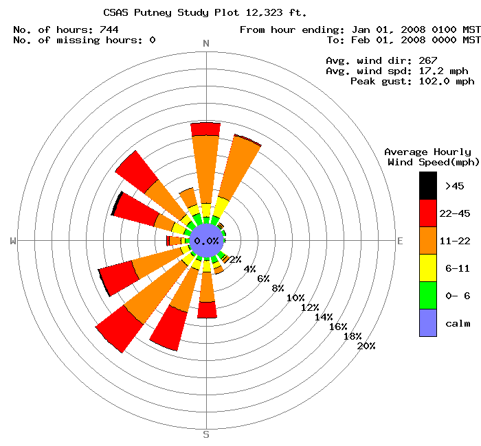
For comparison, the January 2008 wind rose below shows a much broader distribution of wind direction. Note, also, the very high peak gust value (our record gust at Putney is 108 mph). Still, January 2008 produced no dust-on-snow events either.
As you may recall, February has produced significant dust-on-snow events in the Colorado Mountains, perhaps most famously the February 15, 2006 event (D2-WY2006). As is typical of most dust-on-snow, that event was delivered on strong SW’ly winds, as seen below.
![PTSPwindrose_Feb2006[1].png](http://snowstudies.org/dust/_images/PTSPwindrose_Feb2006.png)
With the recent breakdown of the blocking western high pressure system, re-opening the western and southwestern gates for Pacific storms to reach Colorado, future weather systems may have the opportunity to produce the potent SW’ly wind fields over the Colorado Plateau that often deliver dust to our mountain snowpacks. While no one hopes for our first dust-on-snow event of the season, the southwestern mountains, at a minimum, will need a number of additional large storms to enter the region from the west or southwest in order to eventually develop average Peak SWE in the snowcover. Time will tell whether those same storms will also find dust available for wind transport, as they traverse the Colorado Plateau. However, ongoing drought in that landscape suggests that Colorado dust-on-snow is perhaps inevitably linked to the major winter storms we still need, later this winter and spring.
Chris Landry, Executive Director
clandry@snowstudies.org
Center for Snow and Avalanche Studies
PO Box 190, Silverton, CO 81433 USA
(970) 387-5080
www.snowstudies.org