CODOS TOUR April 12-14, 2021: Significant Dust Statewide, Another Dust Event April 14
Greetings from Silverton,
Unfortunately our statewide CODOS tour this week was relatively easy in the sense that we did not have to dig as much due to the skimpy snowpack. We visited CODOS sample sites to assess the evolution of the snowpack in terms of quantity of snow and also the amount and location of dust. This spring season is unique in that dust is very apparent in/on the snowpack on a statewide basis. For the most part the last few years dust storms have largely come out of the southwest, dumping the dust mainly in the San Juan Mountains, and a good bit less in the northern watersheds. This year dust came up from Mexico, hit the mountains adjacent to the Front Range from the east and went as far north as Cameron Pass, achieving a severity that is more typical in Colorado’s southern basins.
Last week’s tour we visited most of the southern sites before a weather system arrived that delivered a few inches of snow primarily in the central and northern regions the evening of April 13. At the Front Range sites on April 14 we observed 1”-4” fresh snow accumulation on dust or ice layers where the dust was just underneath. Since then a few more inches fell in some mountain areas. All this to mean that this fresh snow added a bit of a clean reflective surface to reduce the absorption of solar radiation, thereby slowing snowpack warming and melt.
For each sample site below we offer a brief description of current conditions and what it could possibly mean the remainder of the season. But as mentioned, at all locations dust of moderate severity is very near or at the surface of the snowpack. Spring weather matters, unless we receive continued and measurable snow to keep dust covered - and additional precipitation - we will see rapid snow ablation of the state’s already slim snowpack. Fortunately, the forecast for the next 7 days calls for chances of precipitation nearly every day.
To add to it all, while we were assessing conditions in central and northern Colorado another windy day in the southwest kicked up and brought dust to the southern mountains late in the day on April 14 - constituting dust event #5 at Senator Beck Study Basin. We will get to the field and assess this newly deposited dust following the posting of this update.
In the table below we also summarize the findings for each site. Don’t be mislead by the word “moderate”, this is a general descriptor (light/moderate/heavy) to give a sense of severity in general terms and how bad dust conditions are and can get, dust severity is not as bad as it was in 2009, for example. Under a “moderate” classification there is more than enough dust to very much significantly affect snowmelt timing and rates the remainder of the snow season across the state.
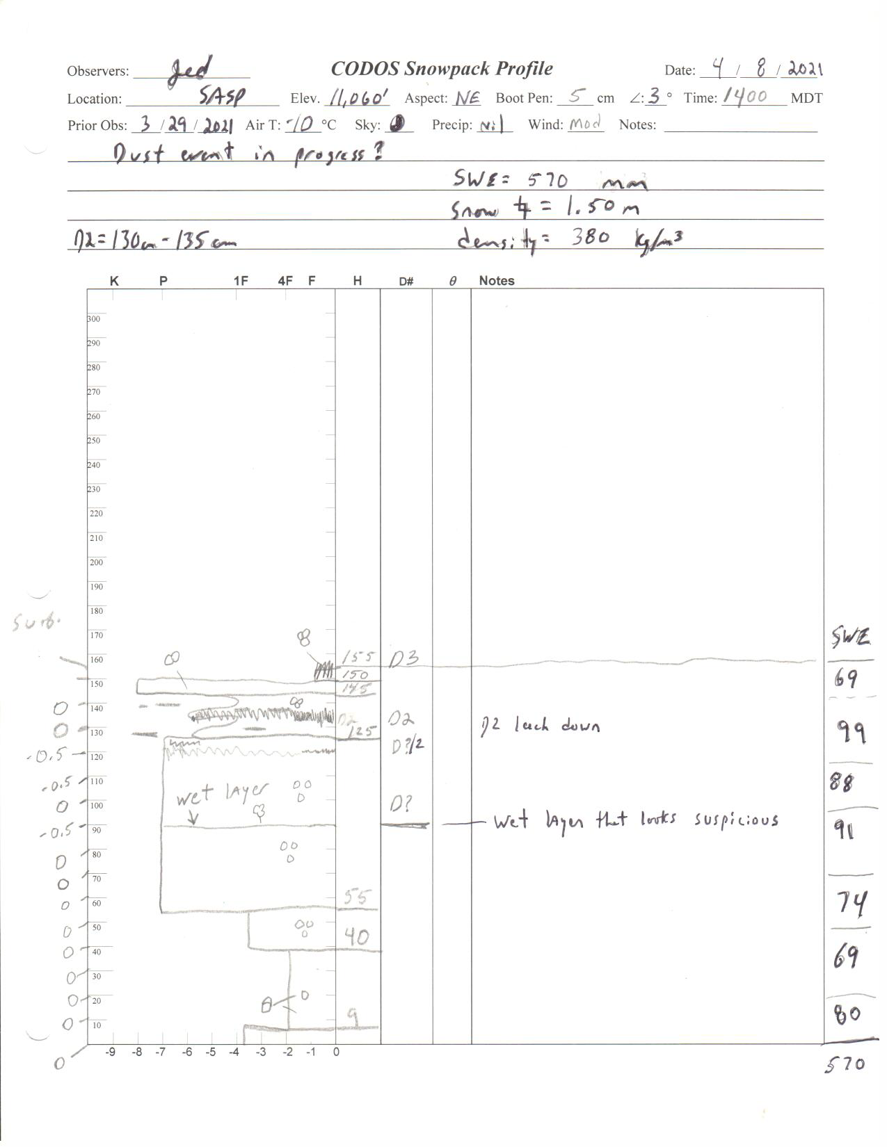
Please see pictures, snow profiles, and summaries below.
Take care,
Below: Table summarizing CODOS site conditions. Except for Senator Beck (12,200’) all sites are isothermal at 0 degrees Celsius. Also note, the number of dust layers is not a good indication of the number of dust events received as some dust layers may have merged together. And also note the comment about descriptor words mentioned above.
Below: Picture of hazy dust event taken by Chris Bilbrey from Peak N2 on April 14. It is located south of Snowdon Peak and northeast of Crater Lake. A number of folks in the southwest area noticed the dust storm and reported dust on their windshields on April 15. This event marks dust event #5 for the season in the San Juans.

Above: Wind rose for dust event #5 that occurred afternoon of April 14 into the evening.
Rabbit Ears Pass - April 13
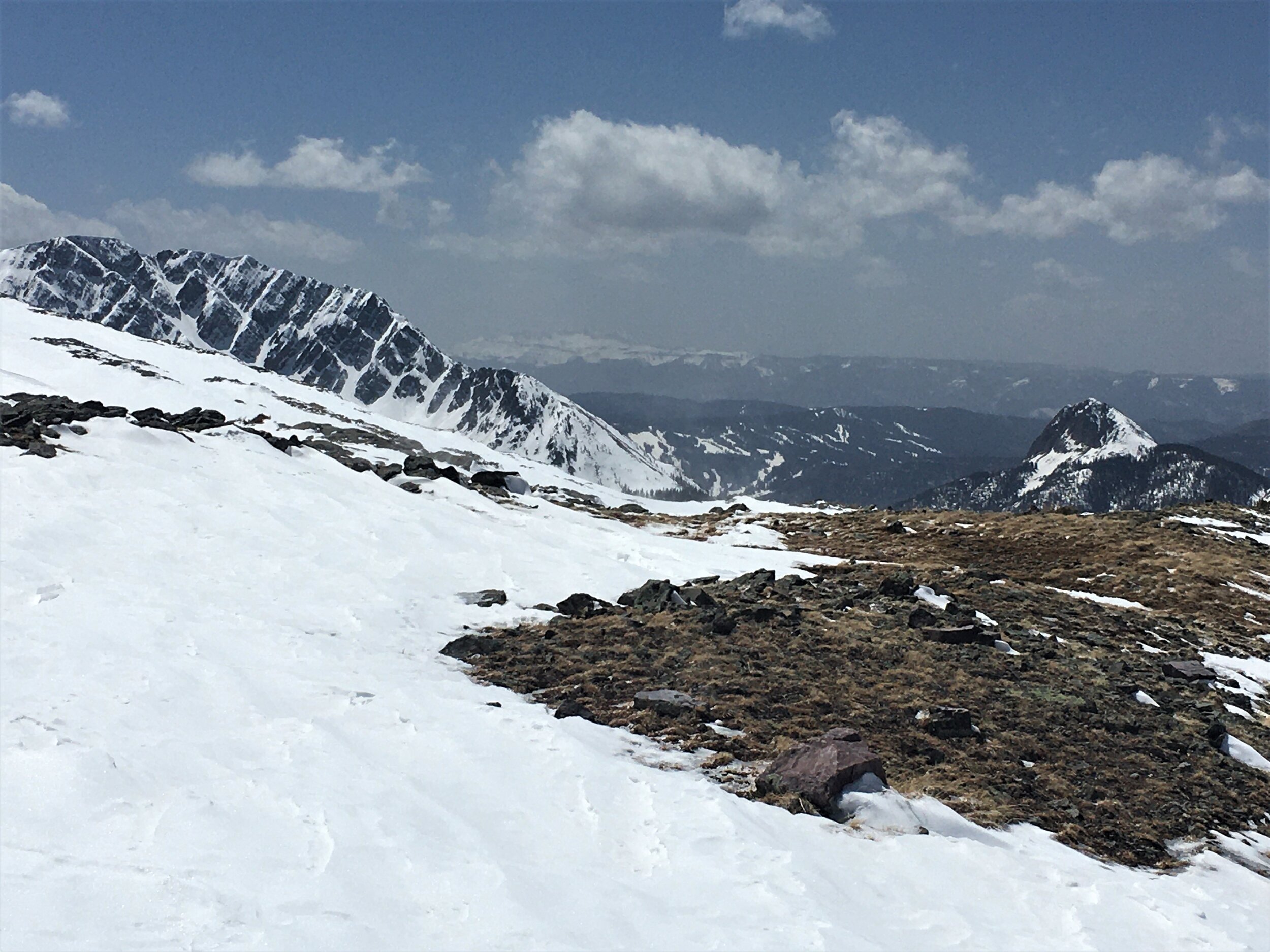
The first thing that struck me on visiting Rabbit Ears Pass is that dust severity is as bad or worse compared to conditions at our Senator Beck sites in the San Juan Mountains, typically uncommon to see. It appears the northwest mountains received dust from the Front Range event and/or events out of the west from the Uinta Basin during high winds during the first part of March. Our visit on April 13 (a day before precipitation fell in the area) we saw a notable and significant amount of dust on the surface and a pretty nasty dust layer a little over a foot beneath the surface. The pictures below clearly show both of these dust layers. Since our visit ~4” of snow accumulation has occurred, which will temporarily cover surface dust. After this weather system moves out it will not take long for the spring sun to expose the dust once again, from there a little over 6” of SWE sits over the buried dust layer - at the location where we did a snow profile. When looking at the SNOTEL data, and considering aspect, elevation, etc., this buried layer needs to be scaled a bit (i.e. being closer to the surface). Total depth = 4.5’, SWE = 19.5”.




Willow Creek Pass - April 14
Visiting Willow Creek early on April 14 we saw the very apparent dust layer newly buried by the overnight 3.5” snow accumulation. Since then SNOTEL data show a few more inches fell. This dust will be also quick to show itself once sunny conditions return. The site lost 3” SWE since our visit in March. Total depth - 2.1’. SWE = 7.6”.


Berthoud Pass - April 14
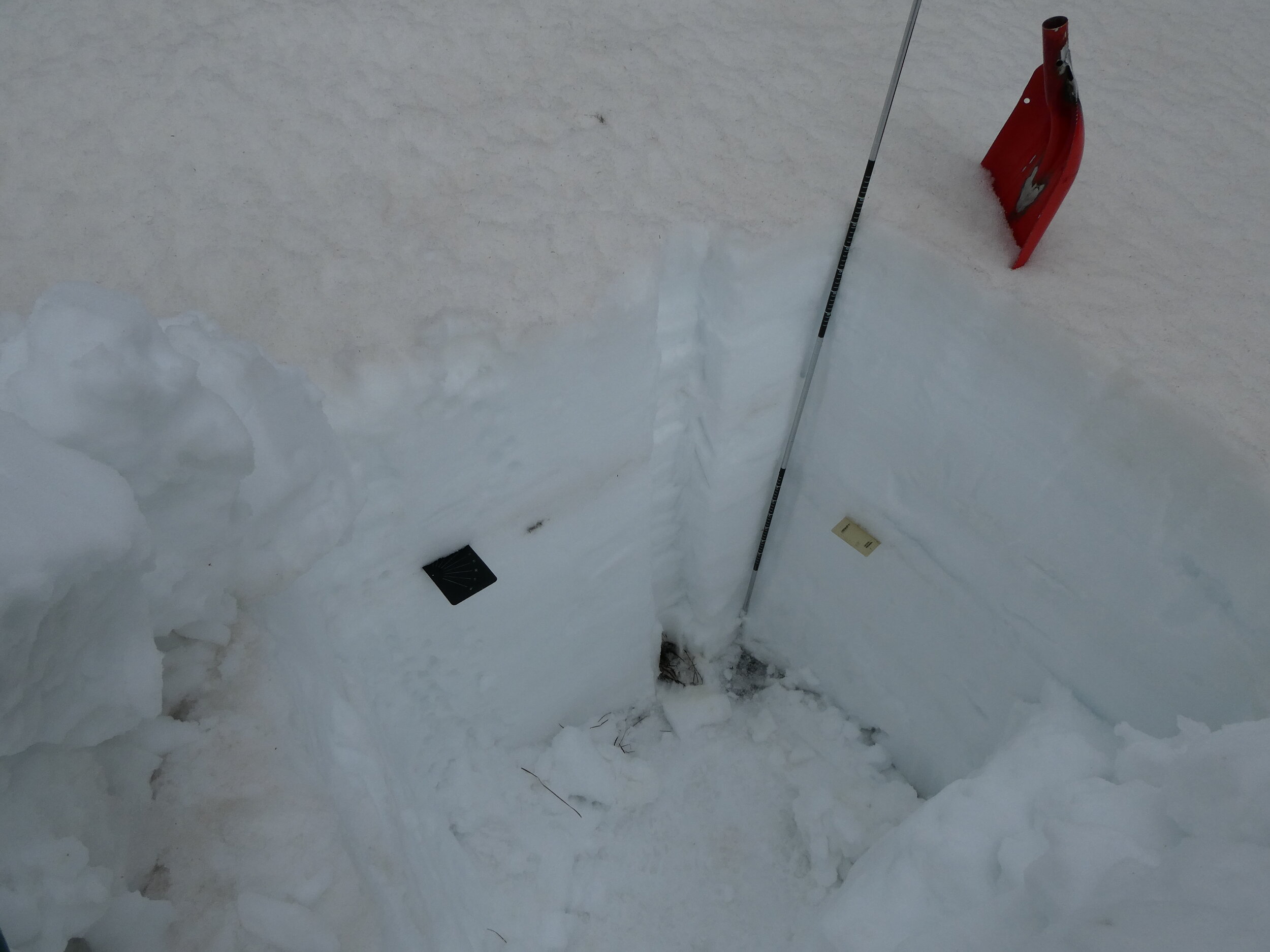
Willow Creek Pass, Loveland Pass and Berthoud really displayed the very orange colored dust from the Front Range event on March 16 strongly. In the first picture below you can see the orange colored dust layer about mid-way up the steel portion of the shovel. 2” of new snow covered the light surface dust on April 14, since then a couple new inches accumulated. The orange dust layer is ~1’ under surface. Total snow depth = 4.7’. SWE = 18.2”.


Loveland Pass - April 14
Loveland is another area that showed the orange dust throughout the landscape, or just beneath a couple inches of new snow from the evening before. The heavy dust layer is a 4” band just under the surface. There is another obvious dust layer 2’ beneath the surface, this of course will surface a bit later in the melt season. Total depth = 4.2’. SWE = 18.2”.


Hoosier Pass - APril 14
Of all the CODOS sites Hoosier Pass had the least severe dust conditions. Light dust exists near surface in the freeze/thaw ice layers, but nothing like Loveland/Berthoud. Total depth = 4.3’. SWE = 17.9”.


Wolf Creek Pass - April 13
Wolf Creek again takes the prize of having the most severe dust conditions. There is dust just under the new snow accumulation that comprises the uppermost ~10”. A dust layer is located in the middle of the snowpack and a layer about 8” up from the bottom. Snowdepth = 4.6’. SWE = 20.5”.


Spring Creek Pass - April 13
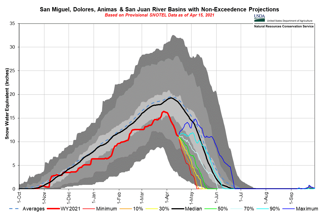
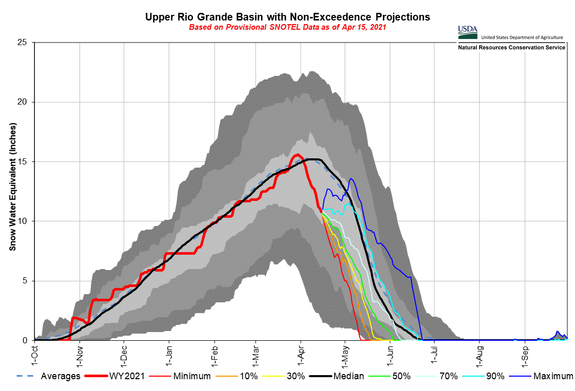
At Spring Creek dust is on the surface, or just below any accumulation since April 13. The nearby SNOTEL does not indicate any accumulated took place. Rio Grande snowpack has depleted rapidly since achieving a nice peak SWE amount the end of March. Snow Depth = 2.2’. SWE = 8.6”.


Park Cone - April 12
Dust sits on a surface melt-freeze crust at Park Cone. Another thin snowpack compared to the norm at and around Park Cone. This site will rapidly melt out once sunny conditions return. Snowdepth = 1.7’. SWE = 6.0”.


McClure Pass - April 12
All dust on the surface as of April 12. McClure lost half of it’s SWE since our visit in March. This is typically the first site to melt of the 12 CODOS sites. Snowdepth = 1.7’. SWE = 6.6”.


Grand Mesa
Given the wind events we seen the last few weeks and the location of Grand Mesa, directly adjacent to high wind events out of the west, dust is not as severe as we expected. Dust is still apparent and on the surface and likely within melt/freeze crusts comprising the top 1’. Total snowdepth = 4.3’. SWE = 18.1”.




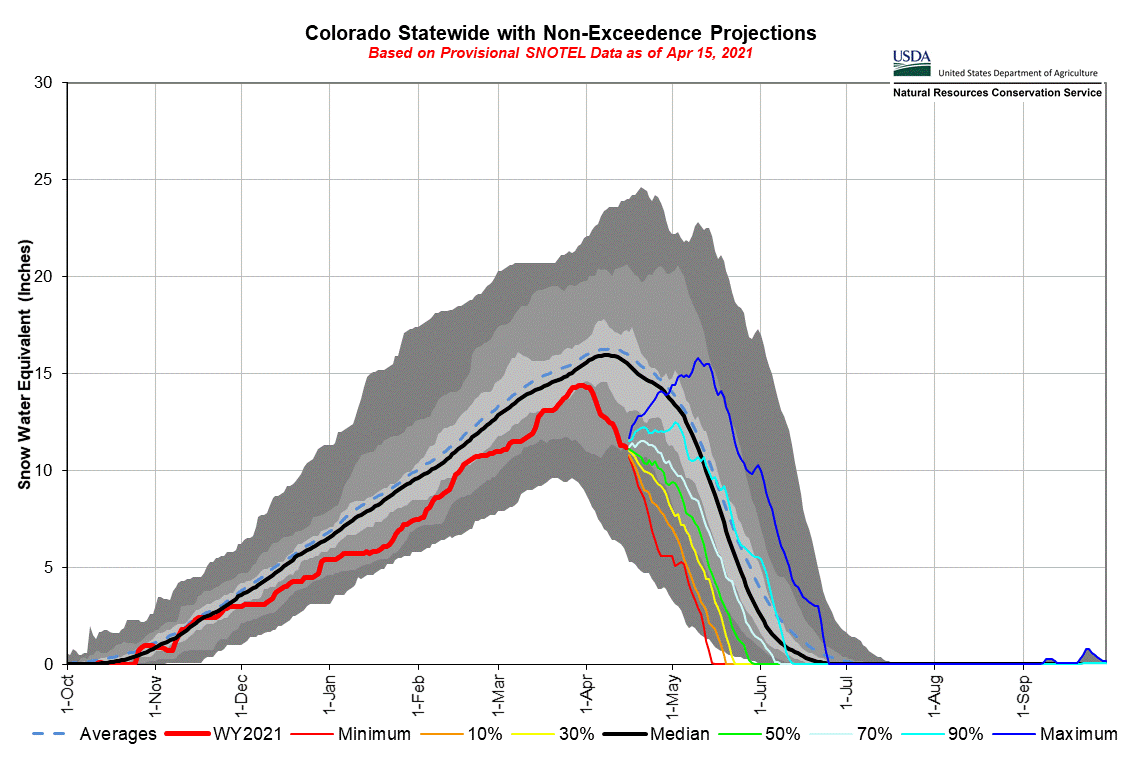
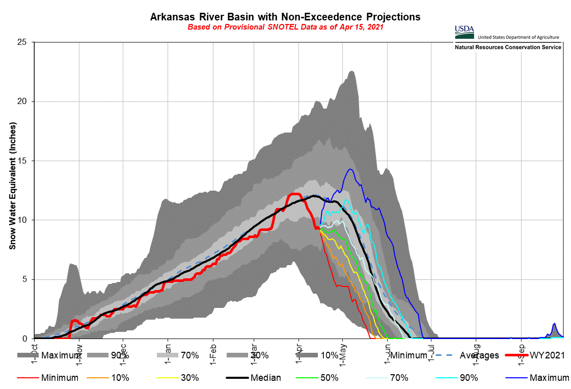
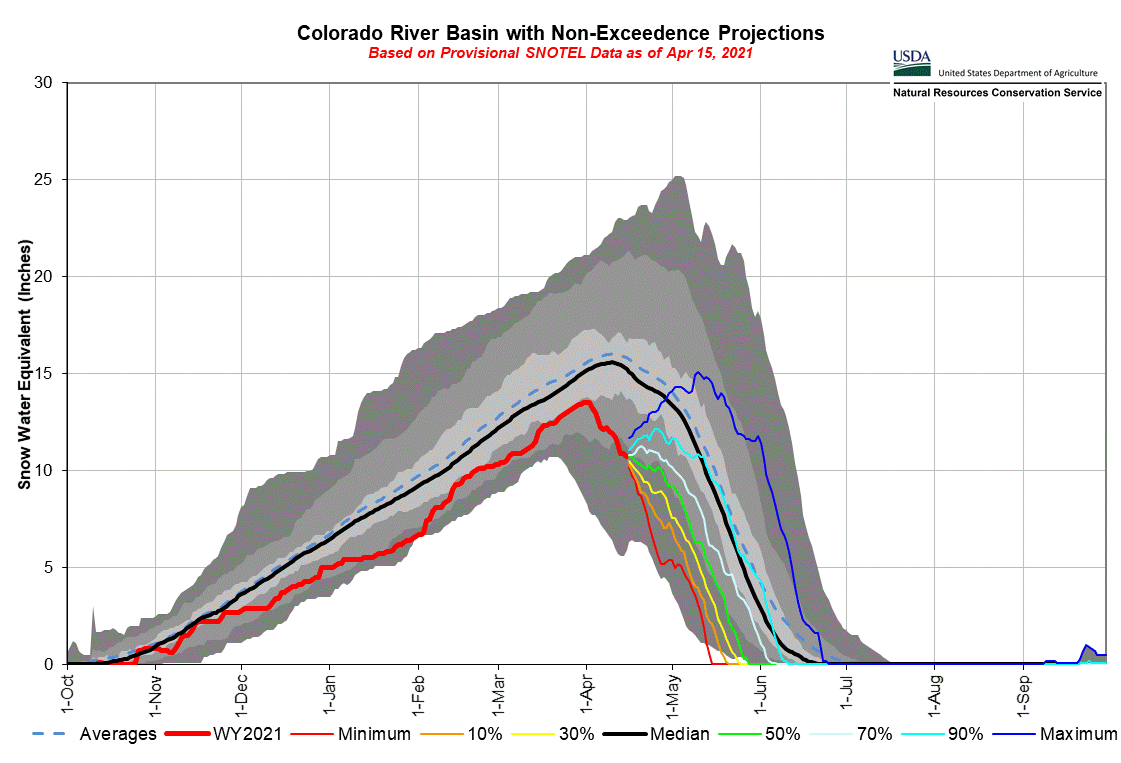
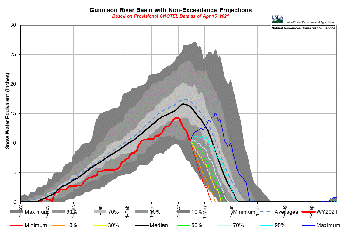
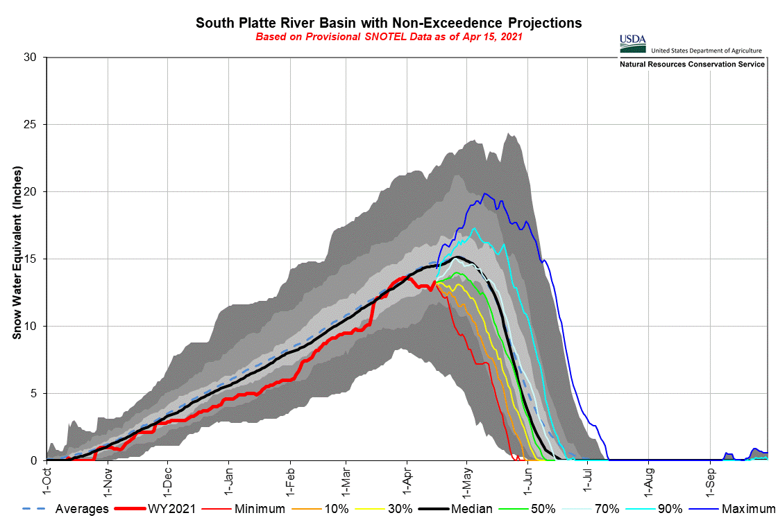
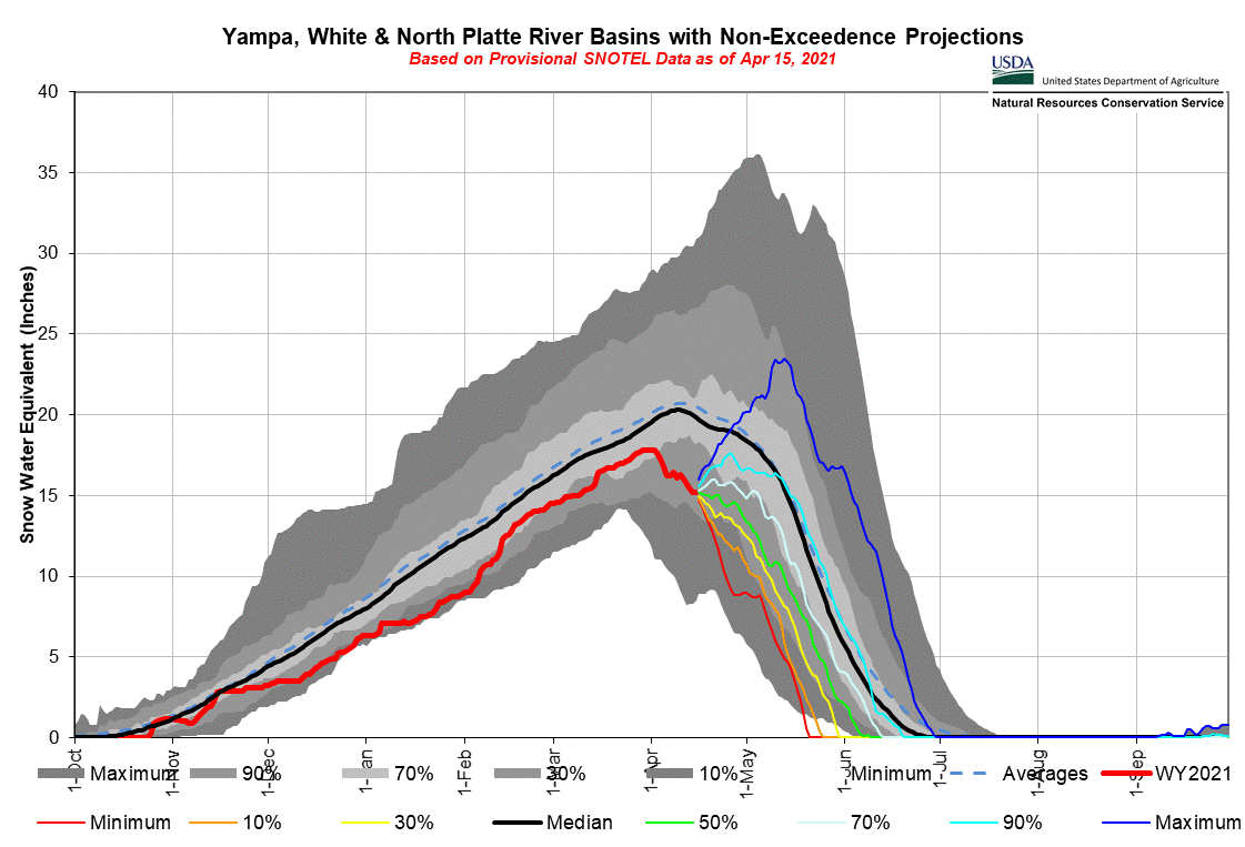
Below: Current SWE conditions by major basin and the state overall.
