

Summary
On March 29, 2014, we measured 23.4” (595 mm) of SWE in our snow profile at the Wolf Creek Pass CODOS site. No significant precipitation has fallen at the nearby Wolf Creek Summit Snotel site since then. Our snow profile revealed the presence of dust event D3-WY2014 in a band located 7” below the snowpack surface, with 95% of the snowcover SWE lying beneath D3. Dust layer D3 was apparent at the snow surface in only a few patches in the locale. Two additional mid-pack dust layers were noted but these will not play a major role in spring runoff behavior. As of April 2, the Wolf Creek Summit Snotel is reporting only 50% of median Peak SWE, at 17.6”; the median date of Peak SWE is May 3. Just to the west, the Upper San Juan Snotel reports 67% of median Peak SWE; mean date of Peak SWE is April 11 there. Near the headwaters of the Rio Grande River main stem, the Beartown Snotel reports just 84% of median Peak SWE; mean date of Peak SWE is April 15 at that site. Overall, as of April 2, the combined Upper Rio Grande Basin Snotel network is reporting only 70% of median Peak SWE, very near the dates of Peak SWE in that basin. To the west, the combined San Juan, Animas, Dolores, and San Miguel basins are reporting a slightly better 77% of median Peak SWE, very close to the dates of Peak SWE in that basin.
Since our Wolf Creek Pass site visit, on March 30 dust event D4-WY2014 fell onto the snowpack, with no significant snowfall covering it. Only minimal cold content remained in the snowpack in our snow profile so exposure of layer D4 will rapidly accelerate snowpack warming to isothermal (to 0.0° C throughout). Although the Rio Grande at Del Norte hydrographs reported normal levels, on April 1, streamflow may begin to surge in response to radiative forcing in dust layers D4 (and D3) leading to rapid snowpack warming and onset of snowmelt discharge as and when D4 (merged with D3) emerge and remain exposed during predicted dry weather. San Juan River flows have already begun rising but future flows may mirror, in pattern, the runoff behavior the Rio Grande.
Snow Profile
At 163 cm (64.1”), this snow cover depth resembled those observed in late March 2012 and 2013 at the Wolf Creek Pass CODOS site. The snowpack presented clear evidence of numerous surface melting episodes over the past weeks and month, with percolation of free water into the middle and lower snowpack forming thick, difficult to neatly excavate ice layers. Snowpack temperatures in this profile were approaching isothermal (at 0.0° C throughout), with a mean snow temperature of -0.7° C; most of the snowpack was moist (snowball snow) and the surface was thawing melt/freeze snow.
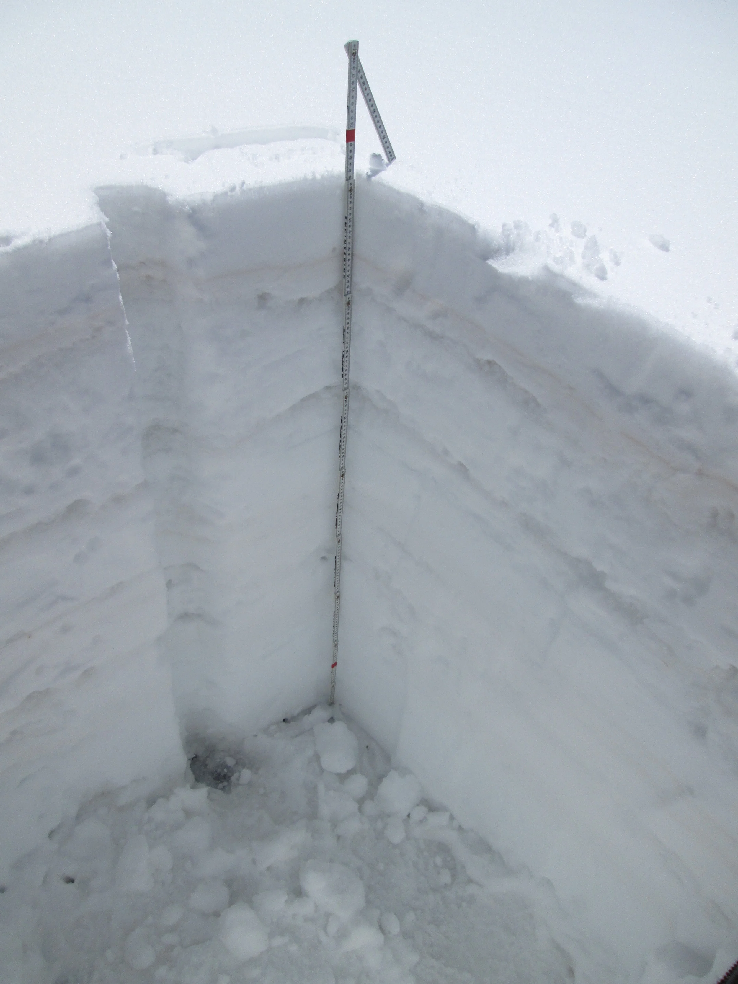
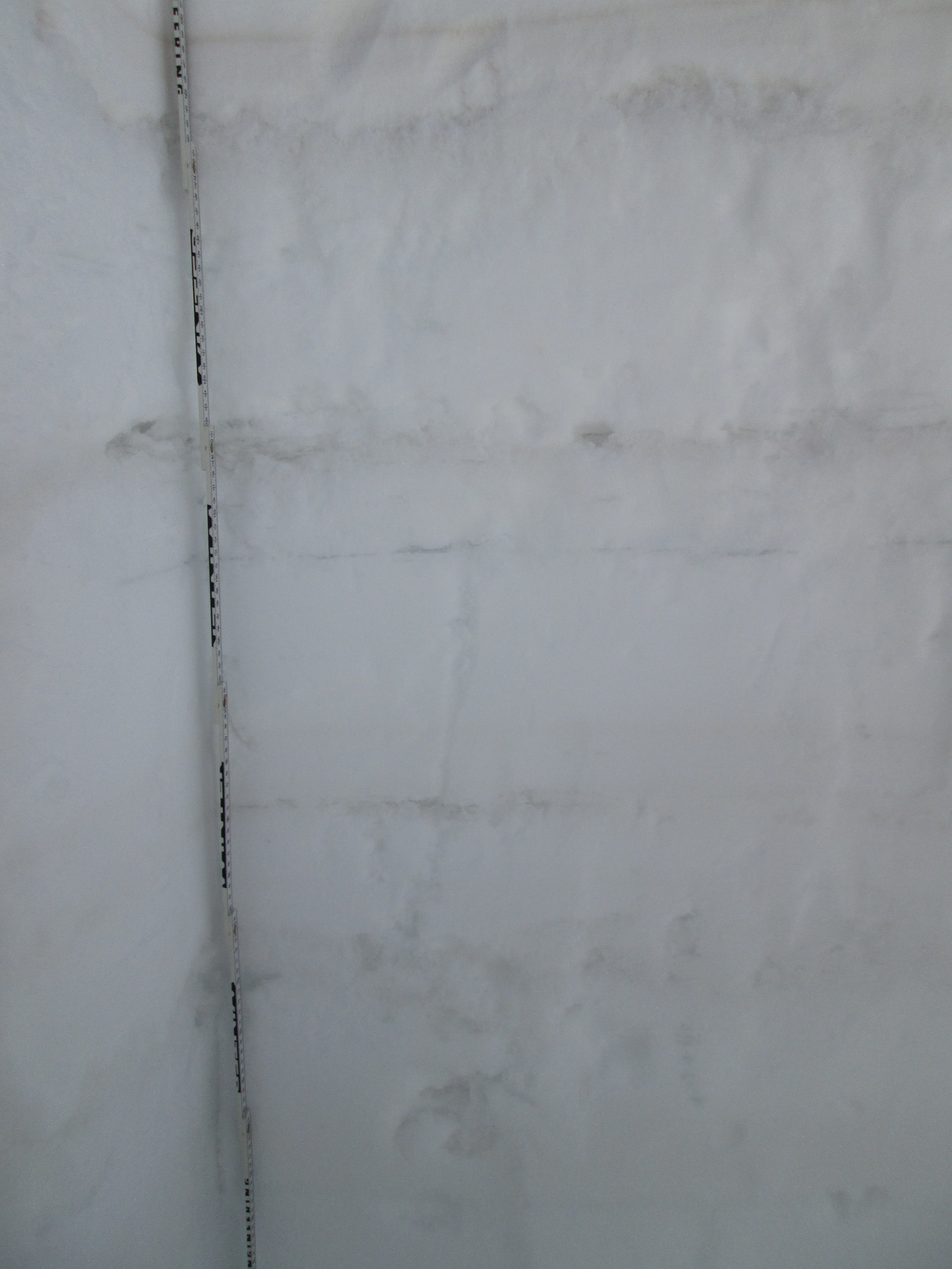
The March 29 snow profile at the Wolf Creek Pass CODOS site. Dust layer D3-WY2014 is clearly visible in a diffuse band 6” below the snow surface. Dust layer D2 may have been present in the thick layer of ice just below D3, but was not visible. Dust layer D4 (March 30) fell onto the clean snow surface seen in this profile, significantly reducing snow albedo until fresh snowfall beginning today (April 2) began to bury D4. Once re-exposed, radiative forcing in layer D4 will need to melt approximately 1” of underlying SWE before merging with layer D3, reducing snow albedo even further.
Two additional dust layers were observed in mid-pack, in snow deposited in late January or early February. These two dust layers were not observed and have no analog at the Senator Beck Basin study area. Their depth of burial will result in these layers having only nominal impact on snowmelt, late in the cycle.
Snotel Plots
Dust-Enhanced Snowmelt Scenarios
As of this writing, within the range of median dates of Peak SWE at Upper Rio Grande Snotel sites, the entire upper Rio Grande Basin displays poor snowpack formation, averaging just 70% of median Peak SWE. Within the framework of the “Snowmelt Runoff Scenarios” table above those SWE totals, as of April 1, place the Upper Rio Grande watersheds in the “Low Peak SWE” domain. Current dust conditions, including event D4, could be characterized as “Moderate” or slightly worse and, should the recent rate of dust-on-snow events continue, dust intensity certainly could attain “Heavy” before the end of snow season.
As of April 1 snowcover on the solar aspects at the Wolf Creek Pass elevation of the southern Rio Grande Basin snowpack appears to have lost most cold content and is on the verge of becoming or already is isothermal and emitting snowmelt runoff. However, given the wet weather and late arrival of dust in March, the Rio Grande at Del Norte hydrograph to-date shows no significant departure from median discharge levels to-date with flows at median levels, as opposed to the early dust-enhanced surging seen in spring 2012, also a poor snowpack year. San Juan River flows, however, did rise to above-average flows in March, but were trending back toward normal levels at the end of March
As always, spring weather will dictate the frequency and duration of dust exposure at the snowpack surface and the consequent impacts of reduced snow albedo on snowmelt runoff timing and rates. As of this writing (Wednesday, April 2) it is currently snowing and 4-8” of accumulation are expected throughout the Colorado mountains through Thursday, April 3, burying dust layer D4 with cleaner snow (which may include an additional, weak D5 event). Unsettled weather will ensue until a high pressure ridge develops to the west by the 8th or 9th.
The NOAA 6-10 day outlook for April 7-11, issued April 1, anticipates substantially below-average precipitation throughout Colorado for that period. A dry period could enable the emergence of the strong dust layer D4 and rapid snowpack warming described above.
NOAA’s 8-14 day outlook foresees a return to normal precipitation conditions. Occasional storms could result in short-term restoration of higher snowcover albedo, and/or could deliver additional dust-on-snow.
Given those forecasts, some slight delay in the onset of Upper Rio Grande Basin snowmelt runoff, from the median timing, may occur. Then, during the expected dry period, exposure of dust layer D4, and merger with D3, will rapidly accelerate snowpack warming where it is not yet isothermal. With dust layers D4/D3 merged and exposed, onset of Rio Grande River runoff may show a rapid mid-April surge, as in the initial surge of 2010. However, this year’s poor snowpack will not be capable of generating the subsequent very large surges seen that 2010 season. Given average spring weather, with a few additional snowfalls in April and May, Rio Grande runoff will more likely mirror the pattern of 2013, with erratic surges to a near-normal but early peak, followed by a steep decline on the descending limb to very low flows.
If April remains drier than average, with prolonged periods of sunny weather and persistently low snow albedo values, very high snowmelt rates may sustain that initial surging to a near- or even above-average peak discharge at an even earlier-than-average date, as most of the snowpack is consumed. Flows could then decline very rapidly, just when “normal” peak flows would be occurring, as seen for the WY 2012 and WY 2013 runoff seasons.
In the more southwesterly San Juan River basin, discharge at the San Juan River at Pagosa Springs gauge has exceeded median levels for several weeks but was recently returning to more normal levels. Given the significantly sub-par snowpack in the upper San Juan watershed, a pattern very similar to that described above may ensue, albeit from a slightly elevated starting point, with surges to an early peak followed by a steep descending limb, depending on spring snowfalls and the frequency and duration of dust exposure.
West Fork Fire Note
This CODOS circuit provided our first visit to the vicinity of the West Fork Fire of summer 2013. As actually observed and photographed in the Papoose Fire terrain, snowcover in the West Fork burned forest is likely extensive and may, in the absence of forest interception and sublimation of snow precipitation, be somewhat heavier than would have been the case without the fire. However, the lack of shading by live trees is also enabling better solar access to the snowcover. This increased amount of comparatively ‘open’ snowpack, and absence of shading by live trees, has increased the proportion of snowpack in the watershed that is subject to the full effects of dust-enhanced, radiative forcing of snowmelt and very rapid snowmelt rates. Some, but certainly not all, of the burned terrain is north-facing, reducing the impact of direct solar radiation. Given the scant snowpack this season, the loss of this fraction of shaded snowpack in the watershed is especially unfortunate.