
Summary
Spring weather has effectively metered the impacts of eight dust-on-snow events in the western San Juan Mountains, parsing the ascending limbs of regional spring runoff hydrographs into a series of surges and retreats. Four winter storms in April and another in May had the combined effects of sustaining substantial snowpacks at higher elevations in the western San Juan Mountains and frequently re-burying dust layers, restoring high snow albedo, and delaying dust effects on snowmelt at those elevations. However, at subalpine and lower elevations several surges in dust-enhanced snowmelt runoff in April and early May consumed a considerable fraction of the regional snowcover. Most recently, dust layer D8-WY2014 has hastened the ablation of the new snow deposited during Storms #23 and #24 and the re-emergence of the underlying merged dust layers D3-7. Large-scale reductions in snowcover albedo resulted on solar aspects at all elevations. North aspects continue to lag behind in revealing merged D3-7 dust. Another strong surge in runoff ensued over the past week but may be moderated by unsettled weather over the Memorial Day weekend before resuming during the remainder of May. Overall, Snotels in the western San Juans have lost the majority of this season’s Peak SWE. Snowcover from alpine terrain will sustain the remainder of the Spring 2014 runoff. In the absence of additional significant snowfalls, merged dust layers D3-8 will result in very low snow albedo values for the duration of the snowmelt cycle, significantly accelerating the rate of the remaining runoff and steepening the descending limb of the spring hydrographs in the region.
Snowpack and Dust Layers
Snow profiles performed in Senator Beck Basin on May 21 illustrate the effects of elevation, albedo, and Storms #23 and #24 on the Spring 2014 western San Juan Mountain snowmelt cycle. Profile #20 was conducted early on the morning of May 21 at the Senator Beck Study Plot, at 12,180’ and Profile #21 was performed at the Swamp Angel Study Plot at 11,060’ later that morning (see below). Both study sites slope 2-3° to the NE.
The following table summarizes the significant differences (and similarities) between the two snow profiles, and with the preceding profiles at the two sites.
Property |
SBSP - Profile #20 |
SASP - Profile #21 |
Snowpack temperature |
Isothermal |
Isothermal |
Change in SWE since last pit |
-1 mm since May 6 (Pit 17) |
-109 mm since May 14 (Pit 19) |
Dust layer D8 |
At snow surface, ‘solo’ |
Merged with D3-7 at surface |
Merged dust layers D3-7 |
Buried under 2.6” SWE (clean) |
At snowpack surface |
Albedo (BB) mid-day May 21 |
0.61 (61% reflectance) |
0.42 (42% reflectance) |
As shown in the table and figures above, at the Senator Beck Study Plot (SBSP) merged dust layers D3-7 remain well buried by recent snow and the snowpack SWE remained effectively the same on May 21st as on May 6th, with Storm #24 offsetting snowmelt losses. At Swamp Angel Study Plot (SASP) more frequent dust exposure and higher snowmelt rates have completely ablated the Storm #23 and #24 and other minor snow layers (a total of 3.5” of SWE) that fell above merged dust layers D3-7, and layer D8 has merged with that dust. The elevation difference of 1,120’ between the two study plots, and the slightly later date when SBSP became isothermal, partially explains those differences; solar exposure is, if anything, slightly higher at SBSP than at SASP. Wind effects on snowcover may have also developed thicker and tougher Storm #23 and #24 layers at SBSP, providing better shielding from radiation for the merged dust D3-7 layer.
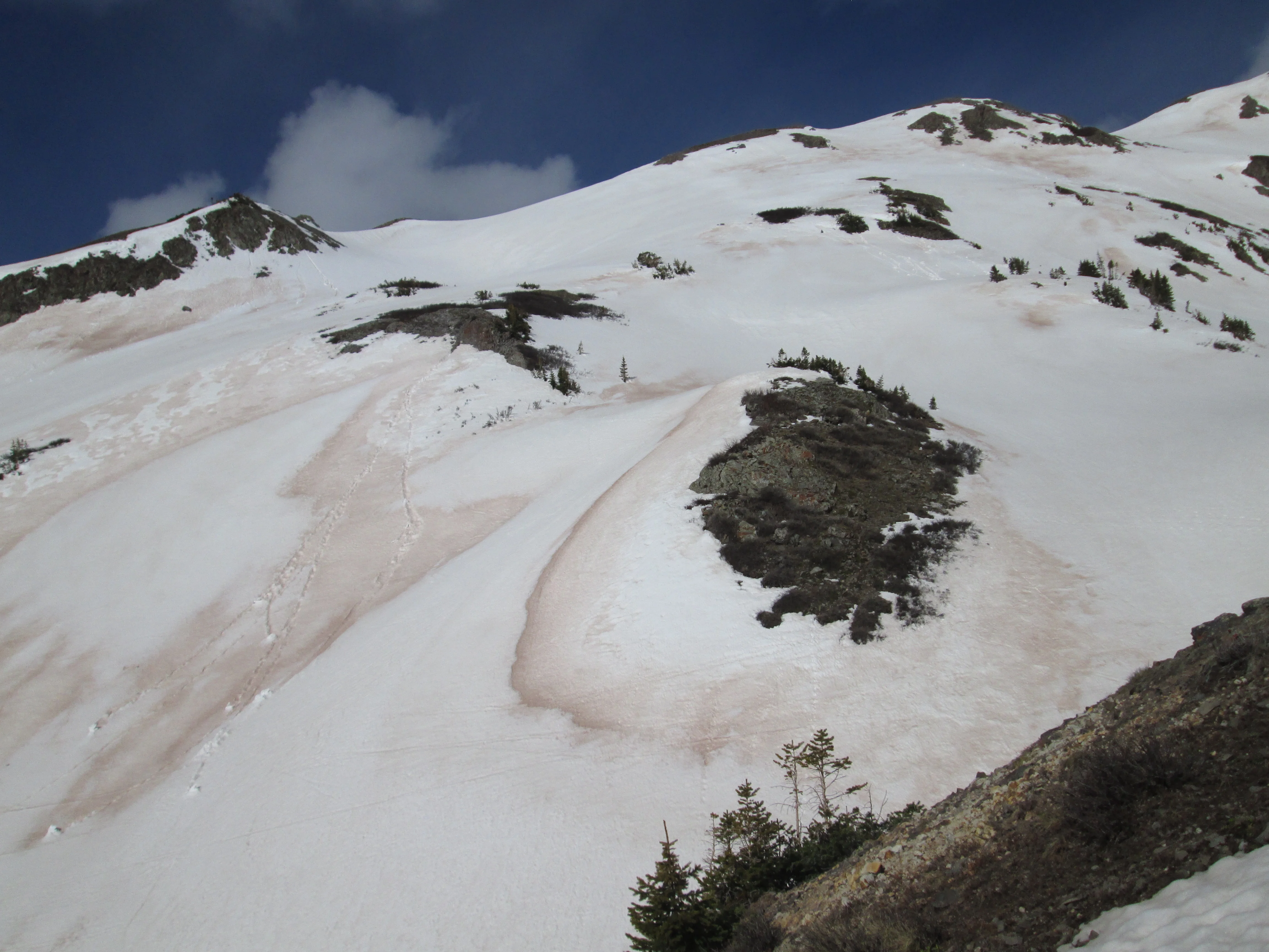
Despite the presence of layer D8 at the snowpack surface, on May 21 albedo in most of the alpine portion of Senator Beck Basin was still substantially higher than in the subalpine, with only widely scattered, wind-stripped patches of merged D3-8 dust exposed.
Andrew Temple approaching the Senator Beck Study Plot, at 12,180’, on May 21st. Dust layer D8 was widespread and is clearly evident on the snow surface to the right of the tower. The very dirty patches below the distant ridgeline are merged D3-D8 dust. Much of the dust in the alpine terrain in Senator Beck Basin is still buried underneath Storm #23 and #24 snow but dust layer D8 is accelerating the ablation of that cleaner snow. Mid-day albedo was 0.61 (61% reflectance), reduced by dust layer D8 only.
On south and southeast-facing alpine terrain, Storm #23 had settled and thinned. Between the fraction of solar energy penetrating that recent snow and reaching the underlying merged D3-7 dust, and the full complement of solar energy absorbed directly in dust layer D8, enough melt occurred to initiate “wet-loose” avalanches and reveal the underlying D3-7 dust layer.
On south and southeast aspects in Senator Beck Basin, absorption of solar energy in dust layer D8 produced enough melt to initiate extensive “wet-loose” avalanches scouring down to the underlying merged D3-7 dust layer.
Below treeline, albedo was very low on all but north-facing, tree-covered terrain, as seen below.
Albedo (broad band) at Swamp Angel Study Plot was 0.42 (42% reflectance) at mid-day on May 21; albedo values fell as low as 0.35 during the spring of 2013, with considerably more dust mass in the snowpack.
Dust mass, as well as dust color and other properties, dictate the impact of dust-on-snow on snow albedo, once fully exposed to solar radiation. As of this date, Senator Beck Basin has received eight dust depositions, only one of which could not be captured in a discrete mass loading sample (D5). The table below, from our Mass Loading data, presents the results for WY 2014 of our in-situ event sampling at Swamp Angel Study Plot and subsequent analysis by our USGS partners, showing a total of approximately 18 grams per square meter of dust loading to-date.

That total-to-date places WY2014 ahead of WY 2011 (14 g/m2) and WY 2012 (11-12 g/m2) and second only to WY 2013 (at an unprecedented 52 g/m2) since CODOS began this labwork collaboration with USGS. Although this 18 g/m2 is certainly sufficient to have significant impact on the remainder of the snowmelt cycle, dust season may not yet be over and dust events in late May and early June have occurred in years past (see the CODOS Dust Log).
Snotel
As previously discussed, snowpack development over the western San Juan Mountains exhibited substantial variation over the winter, to Peak SWE. Although most sites did experience the WY 2014 peak snowpack at a date close to the median, basin-wide Peak SWE fell short of the median and mean as the lumped Snotel plot below illustrates. Nonetheless, some locales did reach or even exceed median Peak SWE, such as Lizard Head Pass and Red Mountain Pass, likely the result of northerly storm tracks in early and mid-winter. Farther east, however, the sunny and wide open Upper San Juan Snotel site fell far short of median Peak SWE (as did the nearby, well-shaded Wolf Creek Summit site, not shown). All three Snotels did register the post-peak ‘bonus’ SWE provided by Winter Storms #23 and #24, but March/April/May precipitation was only 81-84% of the 1981-2010 average precipitation for those three months at those three sites.
Now, in late May, snowpack at lower Snotel elevations and below is largely consumed (or “all gone”, as at Lizard Head Pass), leaving snowcover at/near treeline and/or in thick forest cover (as at Red Mountain Pass and Wolf Creek Pass, respectively) and in alpine terrain above the Snotel network as the primary source for sustaining WY 2014 runoff. Snowcover is now isothermal in those areas and as and when snow albedo is reduced by the emergence of merged dust layers D3-8, these remaining snow covered areas will undergo rapid snowmelt under increasingly long days and high sun angles, as well as increasing air temperatures.
Hydrographs and Weather Forecasts
Hydrographs throughout the San Juan Mountains region display several similarly timed surging episodes on their ascending limbs, to-date, including a new surge currently underway. Although those surges, and their subsequent retreats, were of high amplitude, the overall pattern and net discharge in the Animas, Dolores, and Uncompahgre watersheds tracked reasonably closely around median ascending limb levels (the more northerly Uncompahgre watershed may slightly lag the others in this respect).
Peak flows may occur near median timing on the Animas and Dolores rivers, but actual discharge may significantly exceed the median peak if the current surge is not interrupted by significant snowfalls over the Memorial Day weekend, restoring high albedo for a period of time. Again, in the more northerly Uncompahgre watershed, slower emergence of merged dust layers D3-8 may result in a somewhat later date of peak flows, also approximating the median date of peak discharge. Given near-average peak SWE values at the Red Mountain Pass headwaters, and remaining alpine snowcover, the Uncompahgre river watershed may experience only somewhat steeper-than-average descending limbs on their hydrographs, as snowmelt rates are enhanced by dust. In the generally south-facing Animas River watershed, which also shares the Red Mountain Pass headwaters, a notable absence of low elevation snowcover during the past winter suggests that early spring surges in runoff were driven by snowmelt from mid-elevation snowcover, enhanced by event D2. As a result, less mid-elevation snowpack was available to support the third surge in flows in early May and even less will be available as the system peaks and begins its descending limb. Flows in the Animas River may decline sharply following the approaching, above-average peak flow at/near the end of May.
In the more southwesterly Dolores River watershed, where dust event D2 was quite heavy, rapid loss of snowcover in the Lizard Head Pass locale may indicate that the center of the WY 2014 runoff mass has already passed the Dolores River at Dolores stream gauge and that a sharply declining ascending limb may follow a final dust-enhanced peak flow that is likely to exceed the median peak, on or near the normal peak date. Similarly, very high April flows in the San Miguel River could result in an early but above-average, dust-enhanced peak flow followed by an early and steep descending limb.
Farther east, above-average March and April runoff levels combined with sub-par snowpacks in the upper San Juan watershed may also result in sharply falling flows following a final steep surge to an earlier-than-average, dust-enhanced peak flow.
As of this writing, the National Weather Service in Grand Junction anticipates mostly cloudy or cloudy, unsettled weather with rain and snow showers for the greater San Juan Mountains for today and through the Memorial Day Weekend. Only light precipitation amounts, as rain and/or snow, are expected. The expected light amounts of new snow would result in short-lived increases in snow albedo and rain-on-snow would have minimal effects on albedo. A return to sunny and above-average temperatures is expected early next week. In the somewhat longer term, the NWS Climate Prediction Center’s May 21st 8-14 day precipitation outlook for May 29-June 4 foresees near-median precipitation and increased probability of above-average temperatures.