

Greetings from Silverton,
The Senator Beck Basin received its third dust on snow event of the season during the afternoon and evening or March 25th. D3 was a dry event (occurring without accompanying precipitation) which is currently sitting on the surface of the snowpack around Red Mountain Pass. While it appears to be a relatively light event in terms of dust loading, because it is on the surface it is a worrisome layer as we approach the melt season.
Dry DOS events tend to be patchy on a landscape scale because the dry dust on the surface is susceptible to redistribution by winds following deposition. Wet events which occur with precipitation tend to deposit dust in a more uniform layer across the landscape. It is unclear at this point how winds affected distribution of D3. What we do know is that the dust is visible and on the surface, which is always a good reason to keep close tabs on the snowpack.
Additionally, we are still unsure of how D3 was deposited on the statewide scale. During our next CODOS tour we will assess this distribution as we think about the potential impacts of dust on the melt season on the larger scale. This week we observed D2 being a bit more severe (compared to the eastern San Juans) and mostly exposed on the Telluride, San Miguel, side of the mountain. Currently D2 at SASP (11,000') is still ~16" below the surface, but has revealed itself more so in wind swept and shallower snowpack (lower elevation) areas.
Below is the wind rose for D3.
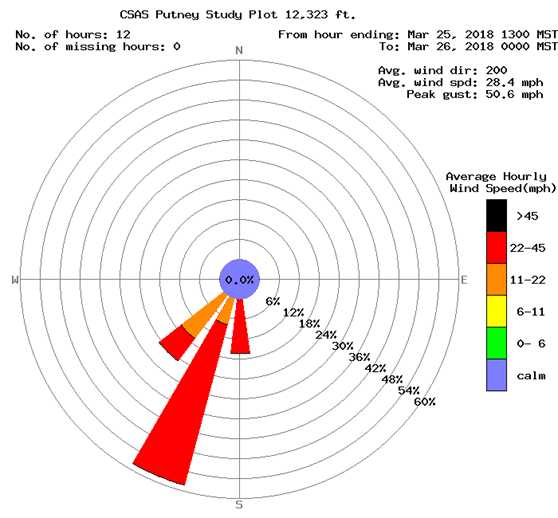
Senator Beck Basin
As we move into spring CSAS will be spending far more time at our local study plots in the Senator Beck Basin. We will be digging snow pits at the Swamp Angel Study Plot weekly and at our higher elevation Senator Beck Study Plot as often as weather allows. We have also installed our stream gauge at the basin pour point for the season, and hope to capture the full seasonal flow cycle for our basin. Those data will be available on our website.
In addition to monitoring dust and SWE in our study basin we are watching closely for Isothermal snowpack temperatures, which is a clear signal of the approaching melt season. We post all of our Senator Beck Basin snow pits on our website so you can track the snowpack progress here: http://www.codos.org/sbb/#snowprofiles-sbb
Streamflow
Most of the discharge sites that we monitor have not seen notable increases in streamflow yet this spring. As we move into spring we expect to see smaller and lower elevation streams and rivers respond to snowmelt first, followed by larger and/or higher rivers which take more water input or warmer temperatures to see significant flow increases. Many rivers have just begun to be gauged for the season, so while our statewide discharge dataset remains slim it is a useful tool for us in keeping tabs on statewide snowpack from here in Silverton.
One river that has seen a spike already this season in the Crystal River, which is gauged near Redstone. This surge in flow was likely caused by a rain event which would have coincided with our Winter Storm #11 here in the Senator Beck Basin. While this was in no way a major flooding event, it is a good example of the flow regimes that we are watching for as we move into spring.

Weather Outlook
With the entirety of the Southwest United States experiencing a severe drought any precipitation we can pick up in the Four Corners region will be much appreciated. Currently there is a large scale atmospheric river event building out in the North Pacific. There is good model agreement that suggests the majority of the Pacific coast will see heavy precipitation, with Washington and Oregon currently being favored significantly. What is still unclear is how far inland the storm will continue to deliver high intensity precipitation and where that precipitation will be at its heaviest. As AR events move inland they tend to become lower in intensity and also narrower in their impact, so the regions that receive major precipitation become more specific. As the system builds and moves closer to the West Coast there will hopefully be more clarity on what we can expect here in Colorado.
As discussed in previous CODOS updates this year, long range climate models are consistently suggesting that the Southwest US will see above average temperatures and below average precipitation. This coupled with the already severe drought conditions is a worrisome set-up from a few perspectives. First of all, it looks like the low snowpack plaguing much of Colorado will not have the chance to grow significantly as sometimes happens during the spring. Also, the dry desert seems as if it will stay dry through the melt season, which has us thinking about dust. Dry soils are far more available for transport and with soil moisture in the dust source region hovering near historic lows we are heads up for any significant wind event with West or Southwest flow.
Upcoming CODOS Tour
During the early April a CSAS team will be visiting our 11 CODOS sites to assess SWE and dust conditions statewide. This will be our second CODOS tour of the season (read the report from our first tour here: http://www.codos.org/codosupdates/march172017-tgc89)
During the first CODOS tour CSAS teams consistently found low snowpack and SWE conditions as well as two distinct dust layers within the snowpack at all of our established CODOS sites. Snowpack temperatures were within normal realms for the middle of march, but with low snowpack, warm temperatures and dust in the upper layers of the snow we expect to see many sites transition into an isothermal temperature regime soon. Isothermal snowpacks are at or very near 0° Celsius throughout the entirety of their height. This means that the snowpack has begun to melt and we expect to see the SWE in those snowpacks to decline and for liquid water to become far more present within the snowpack. We will assess snowpack temperatures along with SWE and dust presence during this upcoming CODOS tour. Look for our report on that tour sometime after next weekend.
A Final Note on Dust…
While we may not have had a severe dust event in Colorado yet this year, the dust is piling up in Eastern Europe. A serious Saharan dust event turned mountains in Russia and the Caucuses a ghastly orange color. Read about that otherworldly event here: https://www.npr.org/sections/thetwo-way/2018/03/26/596988671/clockwork-orange-why-russian-ski-slopes-are-being-blanketed-in-the-unearthly-col
Also, check out this dramatic avalanche which was initiated due to dust enhanced radiative forcing (dust lowering snow albedo and initiating a melt cycle): https://weather.com/storms/severe/video/avalanche-at-mt-elbrus-in-russia-buries-cars-in-parking-lot
That’s all for now. Check back here for more CODOS updates as spring pushes forward.